


misterg
New Member
Location

 maps.app.goo.gl
Application
Devapps
Description
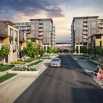
Plan of Subdivision application to create seven blocks for future mid-to-high-rise mixed-use development. The future development proposes to provide approximately1,400 dwelling units, a public park block and multi-use pathway, and a private street.
The subject site, located in College Ward, is situated at the north end of Baxter Road, immediately south of Highway 417. The subject site is approximately 3.13 hectares (31,300 square metres) with 354 metres of frontage along Baxter Road. The site will have direct access to the pedestrian overpass that connects to the Queensview O-Train Station.
The Plan of Subdivision proposes to create seven blocks:
- three blocks for mid-to-high-rise mixed-use development, each with access from Baxter Road and the private street;
- one block for a 20-metre wide private street that will intersect with Baxter Road and provide access to each development block and to the public park;
- one block for a public mutli-use pathway and underground services, with access from BaxterRoad;
- one block for a private drive aisle and underground services subject to an easement, with access from Baxter Road; and
- one block for a public park, with access from the private street and the public multi-use pathway.
Renderings


Google Maps
Find local businesses, view maps and get driving directions in Google Maps.
Application
Devapps
Description
Plan of Subdivision application to create seven blocks for future mid-to-high-rise mixed-use development. The future development proposes to provide approximately1,400 dwelling units, a public park block and multi-use pathway, and a private street.
The subject site, located in College Ward, is situated at the north end of Baxter Road, immediately south of Highway 417. The subject site is approximately 3.13 hectares (31,300 square metres) with 354 metres of frontage along Baxter Road. The site will have direct access to the pedestrian overpass that connects to the Queensview O-Train Station.
The Plan of Subdivision proposes to create seven blocks:
- three blocks for mid-to-high-rise mixed-use development, each with access from Baxter Road and the private street;
- one block for a 20-metre wide private street that will intersect with Baxter Road and provide access to each development block and to the public park;
- one block for a public mutli-use pathway and underground services, with access from BaxterRoad;
- one block for a private drive aisle and underground services subject to an easement, with access from Baxter Road; and
- one block for a public park, with access from the private street and the public multi-use pathway.
Renderings
Last edited: